PicStork Super 30 Challenge
Title: Elevating India's Palm Trees into the Future using PicStork Geo AI and DroneNaksha Ecosystem
India has nearly 102 million palms, with half of them in Tamil Nadu. These palm trees help us with a wide variety of applications from food and beverages, building materials, thatching, palm fiber clothing, and medicine.
In India, palm trees stand as pillars, contributing significantly to agriculture. Understanding the spread of these iconic trees is important since they confront difficulties that affect many sectors. PicStork Geo AI solutions are designed to address these challenges by not only counting palm trees but also providing an elevation profile. This comprehensive approach is essential for making informed decisions and ensuring the health and sustainability of palm trees.
Challenges Faced by Palm Trees in India: Palm trees in India encounter several challenges, ranging from pests and diseases to changing climate conditions. These issues can impact their growth, productivity, and overall health, affecting agriculture and the environment. Addressing these challenges is vital for preserving the role of palm trees in various sectors.
Importance of Elevation Profile: The elevation profile of palm trees offers another dimension of view of their surroundings. This information is crucial for several reasons:
- Environmental Impact: Understanding the elevation profile aids in studying the environmental conditions in which palm trees thrive or face challenges.
- Resource Planning: Elevation data supports informed decision-making in resource planning, such as water management and soil health improvement.
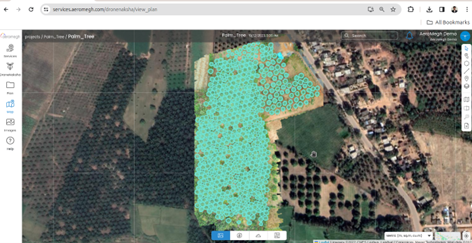
Step 1: Import detections onto your geotiff Using DroneNaksha, you can easily import detected palm trees using various file import options given below:
- shapefile
- kml
- geojson
- import detections from PicStork.
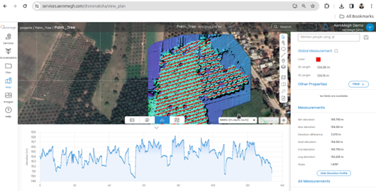
Step 2: Measure Length Using Tool Choose “Measure Length” from the toolbar options provided. Draw Polyline over your palm trees in any desired orientation, either vertically or linearly.
Step 3: Select your Polyline and click on Elevation Profile.
Detector Specifications:
- Number of Detections: 520 Palm trees
- Number of Objects: 1
- Training Time: 30 mins
- Number of annotations count per object: Palm trees: 50
- Number of Images used for training: 1
- Accuracy in Percentage: 91.88%
Applications of Geo AI Solutions: –
- Distribution Mapping: Accurate counting and elevation profiling assist in mapping the distribution of palm trees across landscapes.
- Precision Agriculture: For agriculture, the solution provides insights into the health and growth patterns of palm trees, aiding in crop planning and management.
In conclusion, our PicStork and DroneNaksha Geo AI solutions go beyond counting palm trees; they provide a holistic view through elevation profiling. This approach empowers stakeholders in agriculture, environmental studies, and decision-making processes, ensuring a sustainable and informed approach to palm trees in India.